Compare Grids
Executive Summary
Use this tool to analyze the difference between two gridded Depth/Elevation layers in CSAR/BAG
format. The CSARs and/or BAGs input may
be any combination of variable resolution or raster grids. Output consists of two CSAR grids and three
plot files containing summary statistics.
One CSAR output file contains the simple depth differences in a Diff layer; the other CSAR grid contains
the layer fracAllowError:
the fraction of the IHO-allowable error.
Typical
usage is to compare main-scheme and cross-line hydrography, or the junction
between current survey and other survey.
HSD specifications are met when 95% or greater of the grid-node
comparisons pass. The Comparison
Distribution plot subtitle displays this percentage-pass value (see Figure 4).
Run Instructions
The CARIS BASE Editor batch processing engine
(carisbatch.exe) is required to run this tool.
You must have BASE Editor 4.2+ (i.e., 4.2, 4.3, or 4.4, etc) installed
& configured to run normally. The
NOAA/OCS CARIS software maintenance contract includes the necessary licensing
to install and use CARIS BASE Editor.
See Figure 1. To conduct a surface comparison, first use
the browse buttons to complete all the items on the Run tab. The Depth/Elevation layer in the 2nd
CSAR/BAG file subtracts from the Depth/Elevation layer in 1st
CSAR/BAG file, and the output name populates accordingly:
<1st
Coverage file base name> − <2nd
Coverage file base name>
Edit the
output name shown in the text box to override the default naming, as desired.
Upon
startup, the program automatically searches the host computer for the BASE
Editor batch-processing engine; if found, it is shown
in the dialog and no additional user intervention is required.
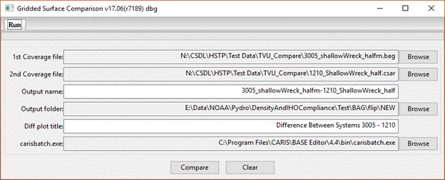
Figure 1 – Example input parameters with default output name according to the
specified 1st & 2nd Coverage files; override the same
default in the Diff plot title as desired.
When you are
satisfied with the input values on the Run tab, press the Compare button to
start the analysis. A green bar just
under the Run tab marks the progress of the program (Figure 2a); any errors
encountered during the process present in a pop-up message window, possibly
directing you to examine the Command Prompt window that accompanies the
application (Figure 2b).
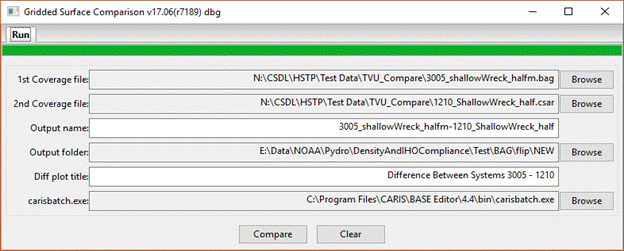
Figure 2a – A successful run with the progress bar at 100%; see also Figure 3
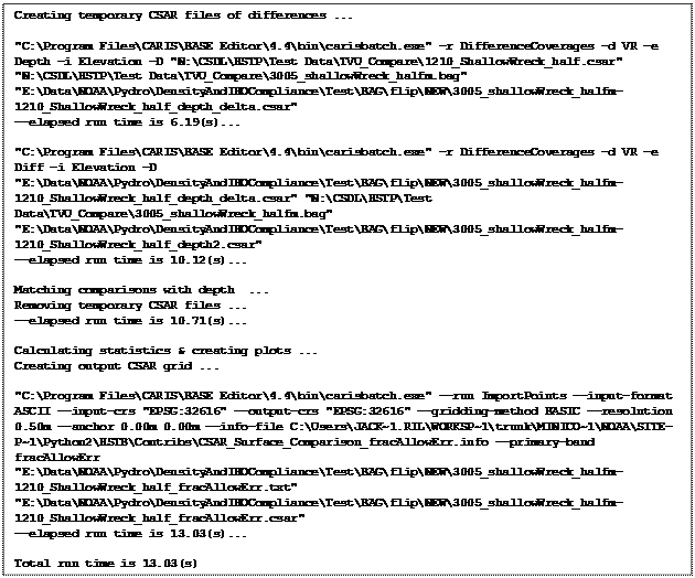
Figure 2b – Example Command Prompt window that accompanies the application.
This window echoes all CARIS batch processing engine commands invoked during a
run.
If you receive any pop-up error messages during a run, additional information
to help
determine what went wrong may be present here.
Results
The output folder contains four (7) files at the end of a successful processing
run:
(1)&(2) – The two files associated with the CSAR fracAllowError output surface
(i.e., the .csar metadata & .csar0 data files),
(3) – A plot of Node Depth (nominal depth of the co-registered
gridded-comparison points) vs. Allowable Error Fraction with summary
statistics,
(4) – A histogram showing the Comparison Distribution of the magnitude of the
fractional allowable errors with summary statistics,
(5)&(6) – The two files
associated with the CSAR Diff output
surface (.csar,.csar0), and
(7) – A stats/distribution summary plot of the Diff CSAR layer
The
Allowable Error Fraction is computed by dividing the
observed difference (1st CSAR file – 2nd CSAR file) by
the IHO-based HSD maximum allowable error for soundings (TVUmax)
scaled according to the variance sum law, assuming independent, identically
distributed observations. The results automatically
handle the TVUmax 100-m depth switchover point for
using IHO Order 1a (0-100m) or IHO Order 2a (100m+).
The
depth-dependent plot (per (3), above; see Figure 3) retains the sign of the
Allowable Error Fraction, where values between-and-including ±1 represent “passing” comparisons; i.e., observational-pair
differences consistent with the maximum allowable error for the given
depth). The histogram plot (per (4),
above; see Figure 4) uses the magnitude (absolute value) of the Allowable Error
Fraction to show a simple indication of what percentage of the total number of
comparisons pass the TVUmax test.
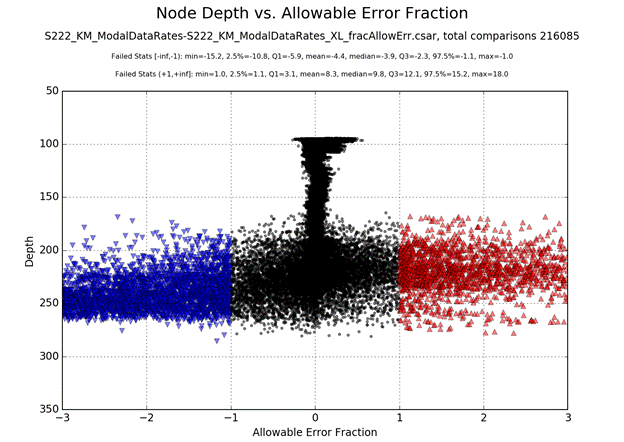
Figure 3 (above)
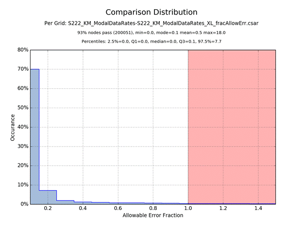
Figure 4 (above)
Open the CSAR output surface (.csar)
in CARIS HIPS or BASE Editor to see the spatial distribution of Allowable Error
Fraction (i.e., layer fracAllowError). Change the Colour
File to FracAllowError [Range] as shown in Figure 5 to
color passing comparisons green, while failed-low and failed-high comparisons
shown in cool (blue shades) and hot (yellow/orange/red) colors, resp (see Figure 6).
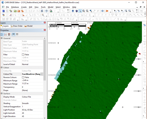
Figure 5 – CSAR output surface
with FracAllowError [Range] color map:
Green = pass
Blue shades = exceeds TVUmax error tolerance, with 2nd
CSAR surface being deeper than 1st CSAR surface
Yellow/Orange/Red shades = exceeds TVUmax error
tolerance, with 1st CSAR surface being deeper than 2nd
CSAR surface
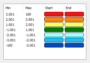
Figure 6
– FracAllowError [Range] color map included with
Comparison Tool
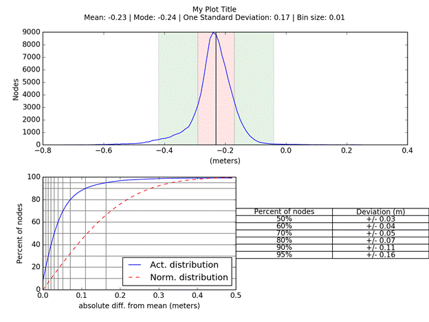
Figure 7 – A stats/distribution summary plot per the Diff CSAR file layer